Background
The aim of the article is to give and idea how to build
robust GIS applications build on .Net and Bing Maps.
Pogo Rent 3000 is a fictional company that hires pogo sticks
round the world. As a consultant, I am asked to help implement GIS
functionality to their web site and to where ever it gives value. Through a couple
of posts I will show how to address this in a pragmatic way. For start the
company wants to show a basic map with great Pogo parks in northern Sweden.
The aim of this article is to describe the implementation of
Pogo Rent 3000. The idea of this project is to provide a solid implementation
of a GIS project based on Bing Maps. The techniques and framework used are well
known and provide a robust foundation for GIS applications.
I strongly recommend using standard formats for
communication with GIS backend is really importance and cannot be stated
enough. The application also showing an example of an endpoint that simulates a
Web Feature Service (WFS from OGC, see http://www.opengeospatial.org/standards/wfs)
or included in the code as a GeoServiceController. OGC formats and protocol
gives flexibility and maintainability.
Application structure
The application is structured the simplest way possible and
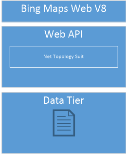
providing a robust platform to extend the system later on. I build a classic
3-tier application.
UI Tier
On top there is Bing Maps V8, it is one of the best map client
out there as today. It provides a straight forward, documented API. More over a
set of spatial function like measuring and a set of modules. A module is
functionality you can extend the web client with. For example, with GeoJSON, (http://geojson.org) support. The small script
that is needed is, for convenience, written in TypeScript. GeoJSON is an OGC
standard since 2016. This means we can add in other datasets from other sources
without worrying about the format as long as it is GeoJSON.
With the GeoJSON module it is super easy to parse the JSON
from the server.
let primitives = Microsoft.Maps.GeoJson.read(geoJSONtext) as
Array;
Service Tier
As service tier I have a Asp.NET Web API. This tier is
boosted with Net Topology Suit (NTS, https://github.com/NetTopologySuite/NetTopologySuite)
which provide a rich set of GIS operations. NTS is great for adding spatial
functions to the application. It also provides GeoJSON support. With this in
place we have the possibility to serve OGC formats.
Data Tier
In this example we use a single text file as data source.
The source is a GeoJSON file. I could of course easily just accessed GeoJSON
file directly through a GET request from the client but for demo purpose I
actually read and parse the file with NTS. The data tier also have an
interface. The idea with the interface is that it should be easy to add other
data sources, for example SQL Server.
Reading GeoJSON with NTS is really simple, here is a snippet
from the application:
var reader = new
NetTopologySuite.IO.GeoJsonReader();
var features = reader.Read<FeatureCollection>(data);
Data is the
GeoJSON. It will parse the json into an object which we can spatial filter,
manipulate compare or do other operations.
Wrap up
With the techniques and framework in place, it is pretty
straight forward to implement. The implementation is as simple as possible and
it provides possibility to extend the PogoRent3000 system. To summarize,
building a GIS application is not different than building any 3-tier
application.
A demo application is online here.
And the code is here
A special thanks to SoulSolutions.


